Hurricane Florence closes in on Carolinas as winds intensify
Hurricane Florence grows in size as coast feels first impacts. Griff Jenkins reports from Atlantic Beach, North Carolina.
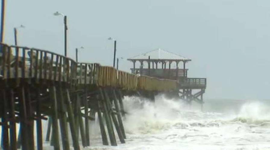
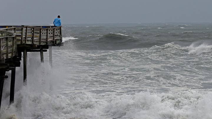
The first powerful winds and rains from a weakened but still dangerous Hurricane Florence began lashing the North Carolina coast Thursday morning, as the monster Category 2 barreled in for a prolonged and potentially catastrophic stay along the Mid-Atlantic region.
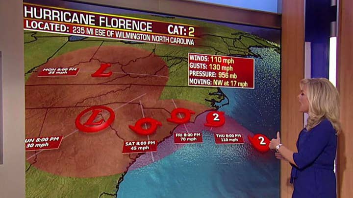
Florence’s winds had dropped from a peak of 140 mph to 105 mph late Thursday morning as authorities urged residents to stay alert about the widening storm’s life-threatening storm surge, tropical storm force winds and catastrophic flash floods.
As of 2 p.m. EDT, Florence was centered about 110 miles southeast of Wilmington, N.C., and about 165 miles from Myrtle Beach, S.C., and moving at about 10 mph.
TRACK HURRICANE FLORENCE'S PATH HERE
FEMA Administrator Brock Long, who at a Thursday briefing accidentally called the storm "Floyd" multiple times, a reference to 1999’s Hurricane Floyd, urged residents in harm's way to evacuate, saying the storm surge warnings have not changed despite the weakening intensity of the wind scale.
“Please heed the warnings,” he said. “Your time is running out.”
North Carolina Gov. Roy Cooper echoed Long’s warnings saying residents should not get complacent and must stay on guard.
“This is a powerful storm that can kill. Today the treat becomes a reality,” he said. “Get yourself to a safe place and stay there.”
He continued: “This storm will bring destruction to North Carolina.”
AS HURRICANE FLORENCE NEARS, LIVE SURF CAM VIDEOS SHOW IMPACT ON CAROLINAS
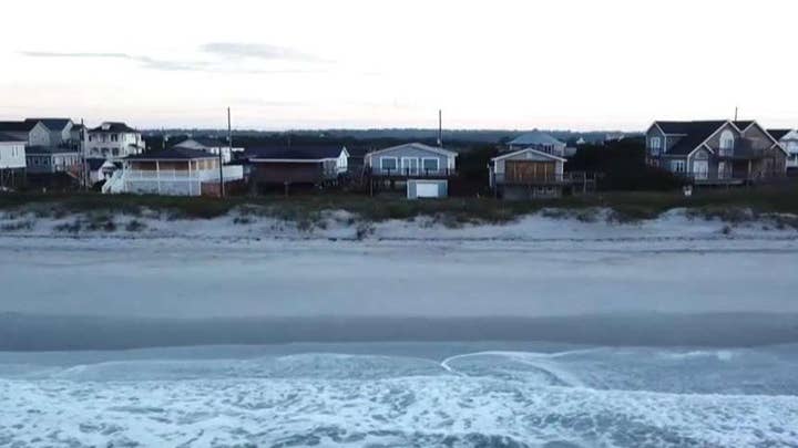
By midday, Spanish moss blew sideways in the trees as the winds increased in Wilmington. On North Carolina's Outer Banks, water flowed through streets and between beachfront homes, and some of the few people still left in Nags Head took photos of angry waves topped with white froth.
Statewide power outages were already reported early Thursday afternoon with more than 12,000 in two North Carolina counties reporting no power, North Carolina Emergency Managment said.
The National Hurricane Center reported that a NOAA reporting station at Cape Lookout, N.C. reported a sustained wind of 53 mph and a gust of 63 mph.

Americans from around the nation offer help to the Carolinas
Groups from around the United States jump into the action to help the Carolinas as the region braces for Hurricane Florence.
David Novak, director of NOAA’s Weather Prediction Center, said the storm surge expected from Florence is “one of the deadliest hazards of hurricanes,” and forecasters predict upwards of a 13-foot surge on parts of the Carolina coast, including from Cape Fear to Cape Lookout in North Carolina.
"If you are in these areas, eastern North Carolina, eastern South Carolina, and you've been told to evacuate," Novak said. "Please do not think you can ride this one out. That would be a deadly decision."
Forecasters said Florence's eye could come ashore early Friday around the North Carolina-South Carolina line. Then it is likely to hover along the coast Saturday, pushing up to 13 feet of storm surge and unloading water on both states.
HURRICANE FLORENCE STRENGTHENS IN ATLANTIC: TIPS TO PREPARE FOR THE STORM
The forecast calls for as much as 40 inches of rain over seven days along the coast, with the deluge continuing even as the center of the storm pushes its way over the Appalachian Mountains.
More than 5.25 million people live in areas under hurricane warnings or watches, and 4.9 million others live in places covered by tropical storm warnings or watches, the National Weather Service said.
“Do you want to get hit with a train or do you want to get hit with a cement truck?” said Jeff Byard, an administrator with the Federal Emergency Management Agency, talking about the different between a life-threatening Category 3 hurricane and a still-lethal Category 2 storm.
HURRICANE FLORENCE EMERGENCY CONTACTS TO NOTE AS STORM HITS EAST COAST
Tornado watches are in effect in parts of southeastern Virginia and eastern North Carolina. The tornadoes should be weak and short-lives, but could add to the damage caused by rainfall or straight-line hurricane winds.
Jeff Masters, the meteorology director of forecasting website Weather Underground, said Florence eventually could strike as a Category 1 with winds less than 100 mph -- but that's still enough to cause at least $1 billion in damage. Water kills more people during hurricanes than wind, and the rain and storm surge is what makes Florence extremely dangerous.
President Trump touted the government's readiness for the storm on Friday and urged residents to gets to safety.
“We are completely ready for hurricane Florence, as the storm gets even larger and more powerful,” he tweeted. “Be careful!”
HURRICANE FLORENCE GENERATING 83-FOOT HIGH WAVES AS IT BARRELS TOWARDS CAROLINA COAST
It's unclear exactly how many people have fled Florence so far, but more than 1.7 million people in the Carolinas and Virginia were warned to clear out. Airlines have canceled about 1,200 flights and that number continued to climb Thursday.
Duke Energy, the nation's No. 2 power company, said Florence could knock out electricity to three-quarters of its 4 million customers in the Carolinas, and outages could last for weeks. Workers are being brought in from the Midwest and Florida to help in the storm's aftermath, it said.
Florence's weakening as it neared the coast created tension between some who left home and authorities who worried that the storm could still be deadly.
Fox News' Amy Lieu and the Associated Press contributed to this report.

The hottest stories ripped from the headlines, from crime to courts, legal and scandal.
